Reading the new State of Forest Report 2019
.
Context
State of Forest Report 2019 has shown a 1,275 sq km gain in very dense forest, but what this statistic masks is the fact that the country continues to lose its best natural forests. A look at what was gained and lost
.
Background
- The report is published by the Forest Survey of India (FSI) which has been mandated to assess the forest and tree resources of the country including wall-to-wall forest cover mapping in a biennial cycle.
- Starting 1987, 16 assessments have been completed so far. ISFR 2019 is the 16th report in the series.
- India is among few countries in the world where forest cover is consistently increasing.
- The total forest and tree cover of the country is 80.73 million hectare which is 24.56 percent of the geographical area of the country.
- Compared to the assessment of 2017, there is an increase of 5,188 sq. km in the total forest and tree cover of the country.
- Out of this, the increase in the forest cover has been observed as 3,976 sq km and that in tree cover is 1,212 sq. km; Range increase in forest cover has been observed in open forest followed by very dense forest and moderately dense forest and the top three states showing increase in forest cover are Karnataka (1,025 sq. km) followed by Andhra Pradesh (990 sq km) and Kerala (823 sq km).”
.
Some Major Findings of the report
- Area-wise Madhya Pradesh has the largest forest cover in the country followed by Arunachal Pradesh, Chhattisgarh, Odisha and Maharashtra.
- In terms of forest cover as percentage of total geographical area, the top five States are Mizoram (85.41%), Arunachal Pradesh (79.63%), Meghalaya (76.33%), Manipur (75.46%) and Nagaland (75.31%).
- The Mangrove ecosystems are unique & rich in biodiversity and they provide numerous ecological services.
- Mangrove cover has been separately reported in the ISFR 2019 and the total mangrove cover in the country is 4,975 sq km.
- An increase of 54 sq Km in mangrove cover has been observed as compared to the previous assessment of 2017.
- Top three states showing mangrove cover increase are Gujarat (37 sq km) followed by Maharashtra (16 sq km) and Odisha (8 sq km).
- The total growing stock of India’s forest and TOF is estimated 5,915.76 million come of which 4,273.47 million come is inside the forests and 1,642.29 million come outside.
- There is an increase of 93.38 million come of total growing stock, as compared to the previous assessment.
- Out of this the increase in growing stock, there is an increase of 55.08 million come inside the forests and 38.30 million come outside the forest areas.
- The extent of bamboo bearing area of the country has been estimated 16.00 million hectare.
- There is an increase of 0.32 million hectare in bamboo bearing area as compared to the last assessment of ISFR 2017.
- The total estimated green weight of bamboo culms is 278 million tonnes, slowly an increase of 88 million tonnes as compared to ISFR 2017.
- Under the current assessment the total carbon stock in country’s forest is estimated 7,124.6 million tonnes and there an increase of 42.6 million tonnes in the carbon stock of country as compared to the last assessment of 2017.
- The annual increase in the carbon stock is 21.3 million tonnes, which is 78.2 million tonnes CO2 eq.
- Wetlands within forest areas form important ecosystems and add richness to the biodiversity in forest areas, both of faunal and floral species. Due to importance of wetlands, FSI has carried out an exercise at the national level to identify wetlands of more than 1 ha within RFA.
- There are 62,466 wetlands covering 3.8% of the area within the RFA/GW of the country.
.
Methodology used for the survey
- In tune with the Government of India’s vision of Digital India, FSI’s assessment is largely based on digital data whether it is satellite data, vector boundaries of districts or data processing of field measurements.
- The report provides information on forest cover, tree cover, mangrove cover, growing stock inside and outside the forest areas, carbon stock in India’s forests, Forest Types and Biodiversity, Forest Fire monitoring and forest cover in different slopes & altitudes.
- Special thematic information on forest cover such as hill, tribal districts, and north eastern region has also been given separately in the report.
- The biennial assessment of forest cover of the country using mid-resolution Satellite data is based on interpretation of LISS-III data from Indian Remote Sensing satellite data Resourcesat-II.
- This information provides inputs for various global level inventories, reports such as GHG Inventory, Growing Stock, Carbon Stock, Forest Reference Level (FRL) and international reporting to UNFCCC, targets under CCD, Global Forest Resource Assessment (GFRA) done by FAO for planning and scientific management of forests.
- For the first time, Ortho-rectified satellite data has been used for forest cover mapping due to its better positional accuracy as it removes effects of image perspective (tilt) and relief (terrain) and scale distortions in the image to represent features in its true positions for accurate measurement of distances, angels and areas.
- FSI, in a first ever attempt has carried out a rapid assessment of biodiversity for all the States and UTs (except two) and for all the sixteen Forest Type Groups as per Champion & Seth Classification (1968).
- Apart from the number of tree, shrub and herb species as observed in the survey, Shanon Wienner Index which gives species richness along with the relative abundance, has also been calculated for each forest type groups in each State & UT.
- FSI has carried out mapping of forest types of India as per the Champion & Seth Classification (1968), for the first time in the year 2011 based on the base line forest cover data of 2005.
.
Other Major Highlights
- A study to assess the dependence of the people living in close proximity to forests for their day to day needs like fuel wood, fodder, small timber and bamboo was undertaken by FSI.
- The present report also gives information on the fire prone forest areas of different severity classes, mapped in the grids of 5km x 5km based on the frequency of forest fires in the last 14 years that would enable the SFDs to manage and control forest fires effectively in the respective States.
- Non Timber Forest Produce (NTFP) are important source of livelihood for many tribal communities and villagers living in the proximity of forests.
- New information has been generated from the national forest inventory data about the top five NTFP species in each State & UT in terms of their availability in forests i.e. relative occurrence.
- Invasive species pose serious threat to the sustainable management of forests. Analysis of NFI data has been done for determining five major invasive species in each State & UT and also an estimate of area affected by them.
- The information given in the report would provide valuable information for policy, planning and sustainable management of forest and tree resources in the country.
.
Objectives of the Nation-Wide Forest Cover Mapping
- To monitor forest cover and changes therein at the National, State and District levels
- To generate information on forest cover in different density classes and changes therein
- To produce forest cover and other thematic maps derived from it for the whole country
- To provide primary base layer for assessment of different parameters including growing stock, forest carbon etc
- To provide information for international reporting
.
Limitations of the Forest Cover Mapping
- Since the resolution of the LISS III sensor data is 23.5 m, land cover features having a geometric dimension less than 23.5 m on the ground are not discernible.
- Considerable ground details may sometimes be obscured due to clouds and shadows. Such areas can be discerned to a certain extent with the help of collateral data and image processing techniques, but not always.
- Non-availability of appropriate season data sometimes puts constraints on the interpretation of the features owing to poor reflectance of data and phenological changes in forests.
- Occurrence of weeds like lantana in forest areas and agricultural crops like sugarcane, cotton, etc adjacent to forests, causes mixing of spectral signatures and often make precise forest cover delineation difficult.
- Young plantations and tree species with less chlorophyll or inadequate foliage, many a times are not discernable on satellite images due to inadequate reflectance.
- Haze and other atmospheric distortions pose difficulty in interpretation, especially in the coastal areas.
.
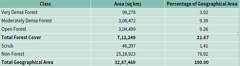
Forest Cover of India
.
FOR OTHER TOPICS – CLICK HERE
If you are looking for best tnpsc coaching centre in coimbatore, best tnpsc coaching centre in coimbatore, top tnpsc coaching centres in coimbatore, tnpsc exam coaching centre in coimbatore , tnpsc coaching in coimbatore , tnpsc training centre in coimbatore , tnpsc group 2 coaching center in coimbatore , tnpsc group 1 coaching coimbatore, tnpsc coaching class in coimbatore , tnpsc coaching centre in coimbatore , coaching classes for tnpsc exams in coimbatore , tnpsc institute in coimbatore , group 4 coaching centres in coimbatore , free coaching classes for tnpsc exams in coimbatore , vao coaching centre in coimbatore , best tnpsc coaching in coimbatore , tnpsc coaching centre in ramnagar coimbatore , tnpsc group 1 coaching classes in coimbatore , government exam coaching center in coimbatore , best tnpsc academy in coimbatore , tnpsc group 4 syllabus, tnpsc model question paper, tnpsc group 4 result, tnpsc group 4 study material, tnpsc group 4 exam, tnpsc vao, tnpsc notification, tnpsc online test, tnpsc group 4 exam date, tnpsc exam details, tnpsc village administrative officer, tnpsc group 4 books, tnpsc materials, group 1 exam, group 4 exam, tnpsc group 4 exam date, tnpsc group 4 online test, tnpsc group 4 question paper, tnpsc group 1 books, tnpsc group 4 books in tamil, tnpsc group 4 model question paper, tnpsc group 2 exam date, vao syllabus, tnpsc exam date, tnpsc latest notification, tnpsc group 4 materials, tnpsc recruitment 2019, tnpsc group 2 books, tnpsc group 2 result, tnpsc online application, tnpsc coaching centre, tnpsc group iv, tnpsc exam guide, tnpsc group 4 online application, tnpsc general english, tnpsc application, group 1 exam 2019, top tnpsc coaching centres in coimbatore , tnpsc group 4 question and answer, tnpsc syllabus, tnpsc tamil online test, group 1 exam date, tnpsc question paper, tnpsc vao exam, tnpsc group 4 application, tnpsc question bank, tnpsc books in tamil, tnpsc group 1 syllabus, vao exam study material, group 1 notification, group 4 online application, group 4 apply online, tnpsc group 4 online application form, tnpsc group 2 exam date 2019, group 4 model question paper, tnpsc group 4 study materials in english, tnpsc online coaching, tnpsc group 1 notification, tnpsc group 4 model question paper in tamil, tnpsc group 4 coaching centre in coimbatore , tnpsc classes in coimbatore , top 10 tnpsc coaching centres in coimbatore , tnpsc vao results, tnpsc group 4 exam details, tnpsc group 1 study material, tnpsc group 4 model question paper with answers in tamil, tnpsc group 1 model question paper, tnpsc group 4 online registration, tnpsc group 1 materials, tnpsc group 4 exam books, tnpsc group 1 mains question paper, tnpsc vao question paper, tnpsc question paper with answer, tnpsc group 2 result 2019, tnpsc group 4 notes, tnpsc answer key, tnpsc group 4 last date, group 2 exam syllabus, vao exam books in tamil, tnpsc group 1 application form 2019, tnpsc group 4 posts details we are here to help