14
Nov
Drainage Patterns and Drainage Systems of India
Drainage Patterns and Drainage Systems of India
- Drainage:
- The flow of water through well-defined channels is known as ‘drainage’ and the network of such channels is called a ‘drainage system’.
- Drainage Pattern:
- It refers to the system of flow of surface water mainly through the forms of rivers and basins.
- The drainage system depends upon factors such as slope of land, geological structure, amount of volume of water and velocity of water.
Types of Drainage Patterns
- Dendritic Drainage Pattern:
- It is the most common form and resembles the branching pattern of tree roots.
- The dendritic pattern develops where the river channel follows the slope of the terrain.
- The pattern develops in areas where the rock beneath the stream has no particular structure and can be eroded equally easily in all directions.
- Tributaries join larger streams at acute angles (less than 90°).
- E.g. The rivers of the northern plains; Indus, Ganga and Brahmaputra.
- Parallel drainage pattern:
- It develops in regions of parallel, elongated landforms where there is a pronounced slope to the surface.
- Tributary streams tend to stretch out in a parallel-like fashion following the slope of the surface.
- E.g. The rivers originating in the Western Ghats; Godavari, Kaveri, Krishna, and Tungabhadra.
- Trellis Drainage Pattern:
- Trellis drainage develops in folded topography where hard and soft rocks exist parallel to each other.
- Down-turned folds called synclines form valleys in which reside the main channel of the stream.
- Such a pattern is formed when the primary tributaries of main rivers flow parallel to each other and secondary tributaries join them at right angles.
- E.g. The rivers in the upper part of the Himalayan region; Indus, Ganga and Brahmaputra.
- Rectangular Drainage Pattern: The rectangular drainage pattern is found in regions that have undergone faulting.
- It develops on a strongly joined rocky terrain.
- Streams follow the path of least resistance and thus are concentrated in places where exposed rock is the weakest.
- The tributary streams make sharp bends and enter the main stream at high angles.
- E.g. Streams found in the Vindhya mountain range; Chambal, Betwa and Ken.
Folding and Faulting
- When the Earth’s crust is pushed together via compression forces, it can experience geological processes called folding and faulting.
- Folding occurs when the Earth’s crust bends away from a flat surface.
- A bend upward results in an anticline and a bend downward results in a syncline.
- Faulting happens when the Earth’s crust completely breaks and slides past each other.
- Whether the Earth’s crust experiences a fold or fault will depend on the material it is made out of in that area.
- A fold is more likely to happen with flexible material and it is what causes mountains to form, whereas a fault will happen with more brittle material and is what causes earthquakes to occur.
- Radial Drainage Pattern:
- The radial drainage pattern develops around a central elevated point and is common to conically shaped features such as volcanoes.
- When the rivers originate from a hill and flow in all directions, the drainage pattern is known as ‘radial’.
- E.g. The rivers originating from the Amarkantak range; Narmada and Son (tributary of Ganga).
- Centripetal Drainage Pattern:
- It is just the opposite of the radial as streams flow toward a central depression.
- During wetter portions of the year, these streams feed ephemeral lakes, which evaporate away during dry periods.
- Sometimes, salt flats are also created in these dry lake beds as salt dissolved in the lake water precipitates out of solution and is left behind when the water evaporates away.
- E.g. Loktak lake in Manipur.
Drainage System of India
Himalayan Drainage System:
- About:
- Rivers of this system are fed both by melting of snow and precipitation and hence, are perennial.
- These rivers form V-shaped valleys, rapids and waterfalls in their mountainous course.
- While entering the plains, they form depositional features like flat valleys, ox-bow lakes, flood plains, braided channels and deltas near the river mouth.
- Indus River System:
- It is one of the largest river basins of the world.
- It is also known as the Sindhu and is the westernmost of the Himalayan rivers in India.
- It originates from a glacier near Bokhar Chu in the Tibetan region in the Kailash Mountain range.
- In Tibet, it is known as ‘Singi Khamban’; or Lion’s mouth.
- The Indus flows in India only through the Leh district in the Union Territory of Ladakh.
- Important tributaries of the Indus are Sutlej, Ravi, Jhelum, Chenab (largest tributary of Indus) and Beas.
- Ganga River System:
- It rises in the Gangotri glacier near Gaumukh (3,900 m) in Uttarakhand where it is known as Bhagirathi.
- At Devprayag, the Bhagirathi meets the Alaknanda; hereafter, it is known as the Ganga.
- The Ganga enters the Northern plains at Haridwar.
- Ganga flows through the states of Uttarakhand, Uttar Pradesh, Bihar and West Bengal.
- Son is the major right bank tributary and the important left bank tributaries are Ramganga, Gomati, Ghaghara, Gandak, Kosi and Mahananda.
- Yamuna is the western most and the longest tributary of the Ganga and has its source in the Yamunotri glacier.
- Ganga flows into the Bay of Bengal near the Sagar Island.
- Brahmaputra River System:
- It is one of the largest rivers of the world and has its origin in the Chemayungdung glacier (Kailash range) near the Mansarovar lake.
- In southern Tibet, it is known as the Tsangpo, which means ‘the purifier.’
- The river emerges from the foothills of Himalayas under the name of Siang or Dihang.
- It enters India west of Sadiya town in Arunachal Pradesh.
- Its main left bank tributaries are Dibang or Sikang, Lohit, Burhi Dihing and Dhansari.
- Important right bank tributaries are the Subansiri, Kameng, Manas and Sankosh.
- In Bangladesh, it merges with the river Padma, which falls in the Bay of Bengal.
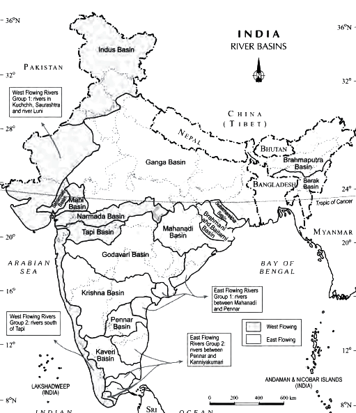
Peninsular Drainage System
- About:
- The peninsular rivers are characterised by fixed course, absence of meanders and nonperennial flow of water.
- The drainage system is older than the Himalayan one.
- The Western Ghats running close to the western coast act as the water divide between the major Peninsular rivers.
- Most of the major Peninsular rivers except Narmada and Tapi flow from west to east.
- The other major river systems of the Peninsular drainage are Mahanadi, Godavari, Krishna and Kaveri.
- Narmada:
- It is the largest west flowing river of the peninsular region flowing through a rift valley between the Vindhya (north) and the Satpura Range (south).
- It rises from Maikala range near Amarkantak in Madhya Pradesh.
- Major Tributaries of the river are Hiran, Orsang, Barna and Kolar.
- The Narmada basin covers parts of Madhya Pradesh, Maharashtra and Gujarat.
- The Sardar Sarovar Project has been constructed on this river.
- Tapi:
- Another important westward flowing river, originates from the Betul district of Madhya Pradesh in the Satpura ranges.
- It flows in a rift valley parallel to the Narmada but is much shorter in length.
- Its basin covers parts of Madhya Pradesh, Gujarat and Maharashtra.
- Mahanadi:
- It rises in Raipur district of Chhattisgarh and runs through Odisha to discharge its water into the Bay of Bengal.
- 53% of the drainage basin of this river lies in Madhya Pradesh and Chhattisgarh, while 47% lies in Odisha.
- Major tributaries: Seonath, Hasdeo, Mand, Ib, Jonking and Tel rivers.
- Its basin is bounded by the Central India hills on the north, by the Eastern Ghats on the south and east and by the Maikala range on the west.
- Godavari:
- It is the largest Peninsular river system and is also called the “Dakshin Ganga”.
- It rises in the Nasik district of Maharashtra and discharges its water into the Bay of Bengal.
- Its tributaries run through the states of Maharashtra, Madhya Pradesh, Chhattisgarh, Odisha and Andhra Pradesh.
- Penganga, Indravati, Pranhita, and Manjra are its principal tributaries.
- Krishna:
- Krishna is the second largest east flowing Peninsular river which rises near Mahabaleshwar in Sahyadri.
- Koyna, Tungbhadra and Bhima are its major tributaries.
- It flows through the states Maharashtra, Karnataka, Telangana and Andhra Pradesh before flowing into the Bay of Bengal.
- Kaveri:
- Kaveri rises in Brahmagiri hills of Kodagu district in Karnataka.
- It is a sacred river of southern India.
- Its important tributaries are Arkavathi, Hemavathi, Bhavani, Kabini and Amravati.
- It flows in a southeasterly direction through the states of Karnataka, Kerala and Tamil Nadu and drains into Bay of Bengal through Pondicherry.